|
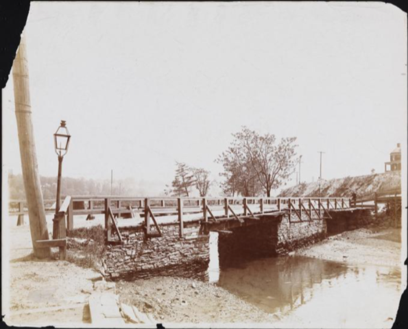
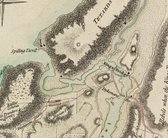
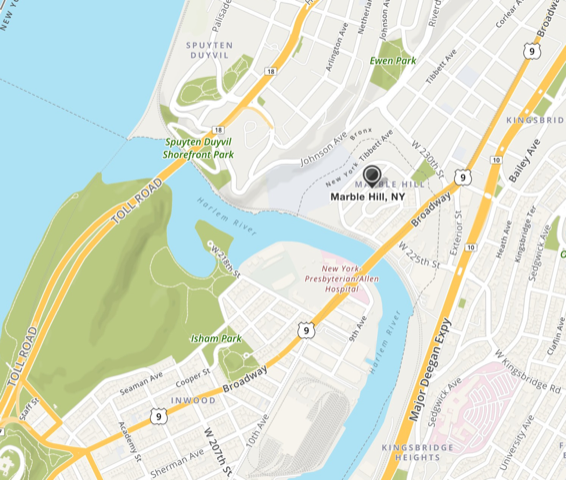
By Alan R. Cohen The geography has been manipulated now, but 500 years ago the Spuyten Duyvil Creek was the narrowest and shallowest water body separating the mainland from the northern end of Manhattan Island. Even so, the Europeans who first settled Manhattan and lower Westchester (now the Bronx) immediately to the north knew that crossing the Spuyten Duyvil Creek posed navigational hazards for boats and difficulties for people fording by foot. The first English Royal Governor of the New York colony, Richard Nicholls, granted land and a patent in 1666 for a fee-based ferry service to connect Manhattan to the mainland. But New Yorkers have always hated tolls. Locals resisted using the ferry. Some tore down fences to gain free access to the creek. Other hardy souls who didn’t have their own boat or canoe chose to gingerly ford the river and swim their cattle across at low tide at a narrow point known as the Wading Place. Scofflaws, when apprehended, were fined. As the population increased, a crossing with greater capacity than a ferry was needed. In 1693 Frederick Philipse, Lord of the Manor of Philipsburg, erected a gated wooden bridge over the Spuyten Duyvil. This toll bridge, known as the King’s Bridge and the first permanent structure to connect Manhattan to the mainland, replaced the earlier ferry service. Philipse collected tolls in the name of King William III. Everyone had to pay the toll to cross the river: farmers and merchants wanting to move livestock or goods between New York City and points north, travelers, virtually everyone. The only people exempt from paying the toll were members of the Philipse family and those in the service of the King, such as soldiers. Locals resented being forced to pay to cross the narrow creek. The last version of the King’s Bridge (ca. 1900), without a toll barrier, before it was buried under landfill. The previous wooden versions had a limited lifespan and were sequentially replaced. (New York, N.Y.). Department of Bridges / Museum of the City of New York. X2010.11.8553. https://collections.mcny.org/Collection/[Old%20Kings%20Bridge.]-2F3XC5I5OK2Q.html Philipse, who had emigrated from the Netherlands and became wealthy when New York was still New Amsterdam, swore allegiance to the British Crown and continued to amass wealth and a great deal of land. Philipse owned property on Stone Street in lower Manhattan, where there were several family homes, and about 200 square miles of what is now Westchester County and the Bronx. The native Lenape had a long footpath in Manhattan that underwent several name changes at different times and locations along its course. One of those name changes—get ready to be confused!—was Kingsbridge Road, because it led to the King’s Bridge. During the British colonial period and for some time thereafter, only two major north-south roads traversed Manhattan: the Bloomingdale Road on the west side and the Kingsbridge Road on the east. The Kingsbridge Road was THE highway, the only road to run the full length of the island. The Bloomingdale Road, which began at the foot of present-day Broadway, ended abruptly near what is now Columbia University. For anyone wanting to leave the city, avoiding the toll on the King’s Bridge posed a challenge. Philipse owned the land most convenient for continuing north from Manhattan. Determined to avoid the tolls, Jacob Dyckman and a partner erected the Freebridge in 1759. In 1776, during the Revolutionary War, General George Washington used both the King’s Bridge and the Freebridge to retreat to White Plains. After the Revolution, both bridges became free. Detail of historic map created to show troop positions in 1776. Dykemans Bridge is the Freebridge. Compare the route of the Spuyten Duyvil Creek, written here as Spiling Devil, to the current map below. Some historians believe that the King’s Bridge may still exist, but it lays buried under tons of landfill. The name Kingsbridge lives on as a section of the Bronx, as does Kingsbridge Road there. Although there is no longer a Kingsbridge Road in Manhattan, the old road that went by that and several other names lives on in Manhattan as St. Nicholas Avenue, running north from 110th Street until it joins with Broadway at 168th Street. Today, if you travel along the Henry Hudson Highway by car, you will have to pay a toll to cross over the ship canal at the northern tip of Manhattan to enter the Bronx. Wading across is not recommended. If you want to avoid the toll on the Henry Hudson Bridge, you must exit the highway at Dyckman Street and make your way over to Broadway, where a free bridge still exists. Contemporary map of the northern tip of Manhattan and part of the Bronx. The waterway was straightened by the U. S. Army Corps of Engineers at the end of the nineteenth century. The area on the mainland labeled Marble Hill (surrounded with a dotted line) was part of Manhattan island before the creek was filled in. The multiple bridges that connect Manhattan on the east side of the island are currently free. But periodically there are proposals to erect toll plazas to feed the coffers of the City. New Yorkers are not happy about that. We’ve never liked tolls. January Tours We're giving in to the weather this month and not scheduling any tours. But you can't keep New Yorkers from walking! If you'd like a private or custom tour, please contact us at [email protected]. Check out our latest blog! Have you ever had a New York Moment? Go to our website, https://www.takeawalknewyork.com/blog, to read Deborah's blog about New York Moments enjoyed by herself, her husband, and a visiting relative.
Comments are closed.
|
Archives
April 2024
|


